Flight Log: Foz do Iguacu SBFI -- Montevideo SUMU 29.01.2018/30.01.2018
 29.01.2018, Iguazu — Montevideo:
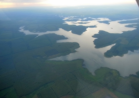
Iguazu’s airfield is very pilot-friendly with a toilet cubicle just 40 metres away from Marie. This makes preparations for take-off a lot easier. Once all the departure papers had been stamped and we’d signed a general declaration and of course paid all our fees, we got into the plane and entered the flight plan into the Garmin. The air traffic controller said a friendly hello and explained what we had to do, when we had to call which frequency and what departure area we had to be on and at what altitude etc. In other words, he went into some detail and wanted us to do everything right. That makes things a lot easier than when you have an air traffic controller who mumbles and isn’t very motivated. However, after about 700 feet we had to fly on in cloud and couldn’t see Iguazu any more. Once we’d reached an altitude of approx. 2,000 metres, we emerged from the clouds and were able to see the Pana reservoir. The Pana river meandered beneath us for at least two hours and the flight route seemed to follow it. We were mainly flying to the tri-border region of Uruguay, Brazil and Argentina. After about two hours flying through a cloudless sky as far as the eye could see, we saw the pampas below us. There are virtually no buildings on them, but vast soy and bean fields. Now and then, we saw vast artificial watering areas that are used as troughs and irrigation repositories. The pictures show that the landscape is similar to that on the Garmin chart in the plane. It’s really easy to recognise it in reality. The further south we flew, the more fields we spotted in Uruguay. This is the sort of structured agriculture that you see in many parts of Europe.
Montevideo appeared after flying for five hours. Viewed from the air, it’s a relatively large city with an urban population of about 1.3 million and about the same size as Hamburg with a port too. The approach flight controller announced that runway 06 was ready for us and that an IFR landing would be required. We entered this into the Garmin and carried on flying by autopilot. However, when we were on the home stretch and approaching runway 06, it started to get a little uncomfortable because the intense rays from the sun whipped up thermal winds from below, causing turbulence and was joined by the wind from the right hand side too. But situations like that don’t of course really put Marie off. We landed as arranged on runway 06 and were taken by a follow-me vehicle to the farthest corner of the airfield where small general aviation planes are tucked away. We were given a very friendly welcome by the team in the follow-me vehicle and our handling agent appeared a short while later to organise everything required.
He immediately warned us however that it could take a little while for the aviation fuel to arrive and we’d have to look out for it. But it didn’t take that long after all and we’d refuelled the plane and were able to proceed with the handling agent to baggage screening and have our documentation checked. Interestingly, the handling agent had in the meantime completed all the immigration formalities in terms of our passports and the general declaration without any customs officials or passport control officers having seen any of the people whose passports they had stamped. That’s all there is to it in Uruguay.
Bye for now.
 Loading. Please wait...


